- Why Mining Matters
- Jobs
- Safety
-
Environment & Operations

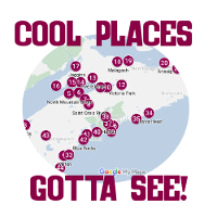
- FAQ
- Links
-
Fun Stuff


It's chilly now but nothing like during Snowball Earth – a deep freeze that took place about 720-640 million years ago. CO2 levels plummeted, earth cooled and was mostly covered in ice.
We know about Snowball Earth thanks to geology. Glacial deposits - rocks that were clearly left by glaciers - suggest there were glaciers at the equator at that time. If there were glaciers in Earth's warmest areas, there were probably glaciers everywhere.
Snowball Earth likely ended because volcanic eruptions under the ice put carbon dioxide back into the atmosphere and warmed earth again. This facilitated the Cambrian explosion about 541 million years ago, in which complex animal life forms appeared on Earth for the first time.
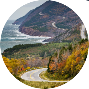
During supercontinent Pangea, the Aspy Fault in the Cape Breton Highlands was likely connected to Scotland's Great Glen Fault, home to Loch Ness.
A fault is where tectonic plates meet. They are often valleys because the rock has been fractured by pressure and movement and weathers more easily.
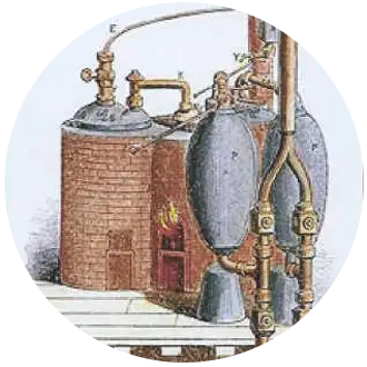
The world’s first commercial steam engine was invented to pump water out of English coal mines.
It was patented in 1698 and ultimately led to the Industrial Revolution.
Today, mining uses high-tech to increase efficiency and safety, and reduce environmental impacts.
Gold was discovered at The Ovens in 1861.
Within two months there were over 600 people panning for gold on the beach and mining the cliffs. The caves/ovens were eroded by the sea but Tucker's Tunnel was extended by mining.
Today the site is a beautiful park.
Mines in Cape Breton towns like Donkin, Glace Bay and Sydney Mines all mined the same huge coalfield - named for Sydney - which extends 300 kilometres offshore.
Morocco has a similar coalfield that may actually be part of the Sydney Coalfield. Nova Scotia and Morocco were connected in supercontinent Pangea and the Sydney Coalfield was likely split between them as North America and North Africa broke apart.
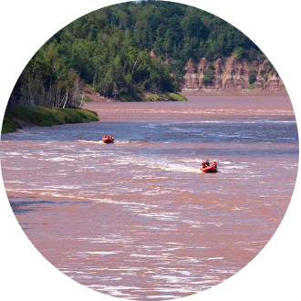
12,000 years ago, receding glaciers made a huge ice dam that blocked the Shubenacadie River from draining into Nova Scotia's Minas Basin.
River water and glacial melt filled the Shubenacadie and Musquodoboit valleys and then overflowed through the Gibraltar Rock gorge.
Rocks change!
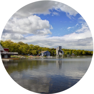
Gypsum and anhydrite are closely-related minerals. The main difference is gypsum contains water and anhydrite doesn't. Gypsum buried deep can turn into anhydrite as it dehydrates. Anhydrite can turn back into gypsum if it absorbs moisture from ground water.
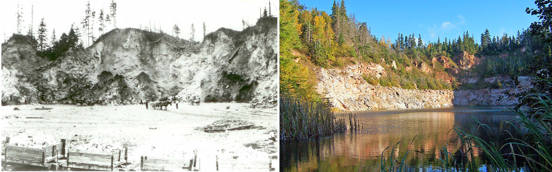
This is the former Walton gypsum quarry in East Hants, Nova Scotia, which started producing in the 1800s and continued until 1972. Today the quarry, like many other former mines and quarries, is a lovely lake.
327-342 million years ago, global sea levels rose and fell many times.
This repeatedly flooded Nova Scotia with what we call the Windsor Sea. NS was near the equator at that time so the sea also evaporated repeatedly in the tropical sun. This process gave Nova Scotia important gypsum, salt and limestone deposits.
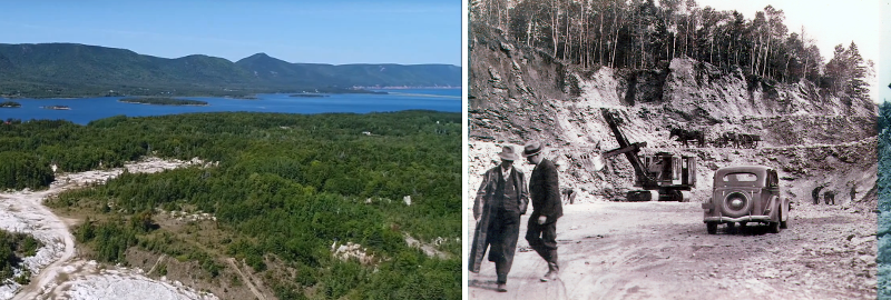
This is the former gypsum quarry in Dingwall.
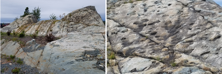
This outcrop at a Sackville office building is metamorphosed sandstone tilted by upward pressure from tectonic plate movement.
Much of it turned from grey to beige due to thousands of years of exposure to weathering. Weathering also hollowed out the oval holes.
"Metamorphose" means "change." In geology, it means rock changed by heat and/or pressure into a new type of rock. Technically, this metamorphosed sandstone is metawacke - a different type of sandstone than what it was originally.
"Metamorphic" comes from the Greek word meaning "to change form."
Most lakes in Nova Scotia, like beautiful Lake Banook, were made by glaciers carving depressions in bedrock that filled with water as glaciers melted.
The last ice age ended 12,000 years ago but there have been glacial periods in NS on and off for at least 500,000 years.
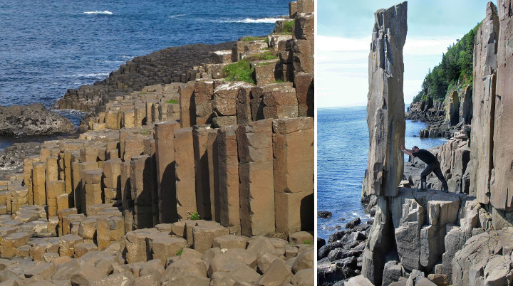
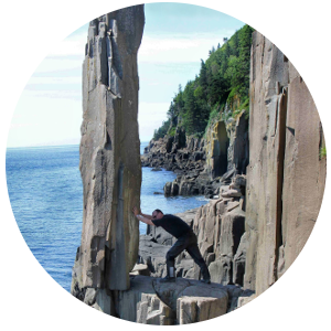
Basalt rock is cooled and hardened lava. Lava contracts (shrinks) as it cools.
Cracks can form, usually in a hexagonal shape, to relieve stress caused by the contracting. This often creates columnar basalt – columns - like this rock on Brier Island and Tiverton's Balancing Rock.
It looks like the set of a science fiction movie but this is The Hammer near Meat Cove, Cape Breton.
The rock formed about 360 millions years ago as rivers deposited sediment that was later compressed into stone. It was tilted over million of years by upward pressure from tectonic plate movement.
As supercontinent Pangea broke up 200 million years ago, lava came out of cracks in earth's crust.
That's how the North Mountain formed: it's flood basalt, or long, continuous sheets of hardened lava overlying softer sandstone. Sandstone not protected by basalt eroded to create the Annapolis Valley.
The North Mountain's basalt is world famous among rock hounds for its zeolites, a mineral used in things like water purification, detergent and cat litter.
Above: North Mountain Annapolis Valley. Below: Blomidon Look Off.
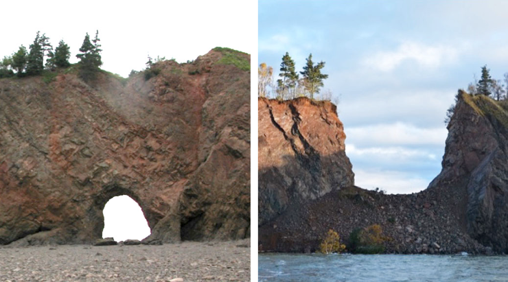
Sea arches and sea stacks are caused by water eroding a hole in a cliff until an arch forms.
Eventually erosion and the weight of the arch's top cause it to collapse, creating a sea stack, or stone tower. The sea arch on Long Island in the Bay of Fundy collapsed in 2015.
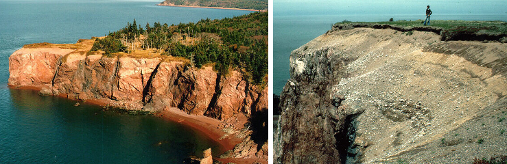
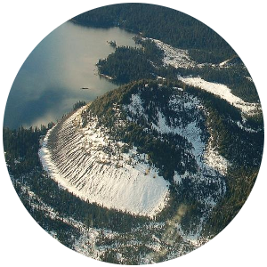
Squally Point in the Bay of Fundy is the highest raised beach in Nova Scotia: 40m above sea level.
Water was never that high. The land was pushed down several hundred metres during the last ice age by the weight of a glacier.
When it melted about 13,000 years ago, the land rebounded, raising the beach.
Glaciers scraped away much of the soil in Halifax during the last ice age, which ended 10,000 years ago.
Only about one metre of it was left in most areas. That's why soil was imported for the Public Gardens, which opened in 1875.
Champlain called it Cape d'Or because he thought copper in the cliffs looked golden.
Mi’kmaq call it L'mu'juiktuk (place of the dogs) because Kluskap's dogs chased a moose there that he turned into Isle Haute.
Mikmaq gathered chert there, a rock whose sharp edges made good tools.
Bedrock is the solid rock beneath surface materials like soil, gravel and ocean.
It's usually many metres underground but can also be seen at surface in outcrops. It's eventually buried, returned to Earth's mantle and melted. It re-emerges as magma to repeat the cycle.
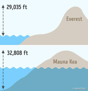
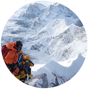
We call Everest the tallest mountain (29,000 feet) but it depends how we measure.
It's the highest peak above sea level because its base is on the 16,000 foot-tall Tibetan Plateau – it gets a huge boost!
Hawaii’s Mauna Kea is taller (33,000 feet) but its base is underwater so its peak is not as high above sea level.
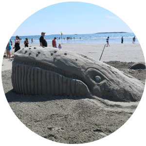
Off to the beach?
Every grain of sand is made by a powerful geological force: erosion.
Freezing and thawing cracks bedrock, ice and water carry rocks down slopes, and water and waves break them down further. Sand is rock eroded over many years.
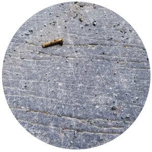
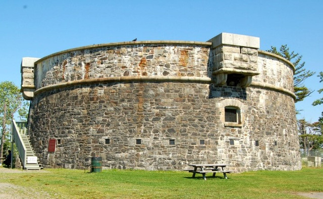
These are striations: ruts made by rocks at the bottom of a glacier scraping the bedrock at Point Pleasant Park's Martello Tower.
Striations are like tracks - they show us the direction in which a glacier moved.
In 1840, journalist and later-Nova Scotia Premier Joe Howe criticized Chief Justice Haliburton so his son challenged Howe to a duel at Martello Tower.
Haliburton fired first and missed. Howe fired in the air. Honour was preserved and no one was hurt.
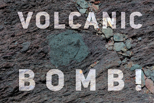
VOLCANIC BOMB!
It sounds like a disaster movie but it's a geological term for molten lava spewed out of a volcano that hardens mid-air and is solid when it lands. The round bit in the middle is a volcanic bomb at Louisburg lighthouse that formed 575 million years ago.
Earth had about 250 minerals when it formed from asteroid collisions 4.5 billion years ago.
Extraordinary heat and pressure transformed rocks into new minerals.
There are about 5400 known minerals today and we find new ones all the time.
Ugh, black fly season.
Still, it's better than 300 million years ago when many insects were giant, i.e. dragonflies as big as seagulls and 8-foot sea scorpions.
More oxygen in the atmosphere (35% compared to 21% now) let bugs evolve and grow larger.
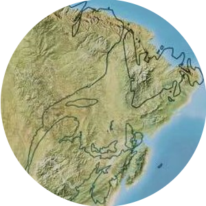
This map shows what North America looked like 77 million years ago compared to now (the black lines show the continent as it is today).
The Atlantic provinces were still part of one landmass, Appalachia. The west coast had not yet joined the mainland.
Tectonic plate movement!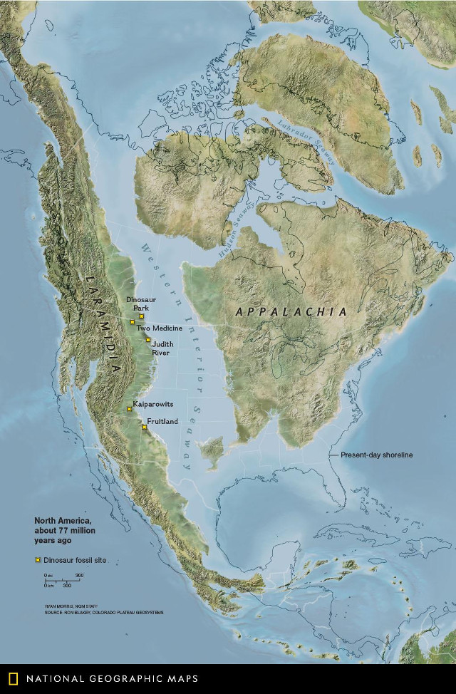
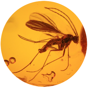
Amber is fossilized tree resin (not sap).
Because resin is sticky, it often traps plants, bugs and small animals before it hardens. Amber fossils are important to growing our knowledge of earth's history because they preserve the whole creature, not just a stone outline of it.
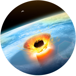
66 million years ago an asteroid killed 75% of life on earth, including non-avian dinosaurs.
But it also created evolutionary opportunity. New mammals like horses and whales evolved.
What if it never happened - how would humans have fared if dinosaurs still ruled earth?!
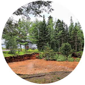
Sinkholes are often caused by minerals naturally eroding in groundwater, which eventually causes the ground above to collapse.
For example, the sinkhole that appeared in Oxford, Nova Scotia, in 2018, was caused by gypsum or salt deposits eroding, which left an underground cavern.
Eventually the weight of the ground above it caused the cavern to cave in.
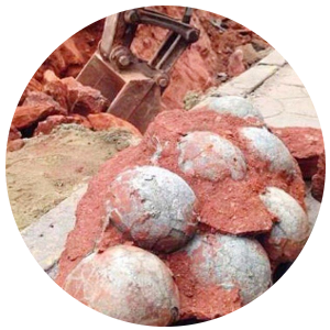
THIS is an egg hunt!
A few years ago a construction crew in Heyuan, China, found 43 eggs. Not Easter eggs - 70 million year-old fossilized dinosaur eggs.
It wasn't unusual. The city holds the Guinness World Record for the largest collection of dinosaur eggs: over 17,000!
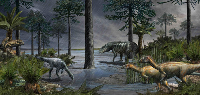
Don’t like the rain? It could be worse.
During supercontinent Pangea most land was desert-like until volcanic eruptions 235 million years ago in British Columbia and Alaska warmed the planet further and caused more evaporation. More evaporation led to more rain: 2 million years of flooding, in fact!
The 2 million years of rain (called the Carnian Pluvial Episode) changed earth forever. It caused a mass extinction but it let conifers (i.e. pine trees) spread and helped some animals, like dinosaurs, flourish. It paved the way for modern lizards, turtles and mammals (us!).
Most life needs oxygen now but it killed most life on earth 2 billion years ago! Algae turned sunlight into energy for the first time (which is called photosynthesis) and made oxygen as waste. It was toxic to the anaerobic (no oxygen) bacteria that were most life on earth then.
We know about the Great Oxygenation Event thanks to geology. The fossil record tells us a mass extinction took place and that oxygen in the atmosphere caused rapid changes in the evolution of life - it helped multi-cellular life form and thrive. Without it, we wouldn't be here!
Also, the large amounts of oxygen in the atmosphere interacted with dissolved iron in the oceans to form banded iron rock - thin layers of iron oxide that fell to the ocean floor and became rock. Most iron deposits around the world are in banded iron formations.
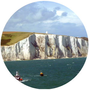
The original Brexit happened 450,000 years ago! Until then Britain was part of mainland Europe - the white cliffs of Dover used to extend all the way to France.
The English Channel was carved into the limestone cliffs by melted glacial water, making England an island.
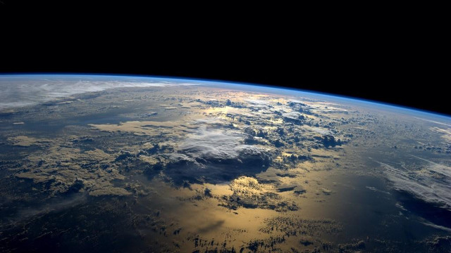
3.9 billion years ago earth was bombarded by meteorites for millions of years.
They contained tiny amounts of water that eventually added up to become our oceans. Water covers 71% of earth's surface.
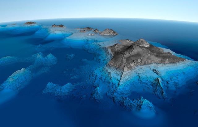
Here's how the Hawaiian islands form: A hot spot under the Pacific tectonic plate vents magma.
It hardens as rock and grows into an island. As the plate moves northwest, the island moves off the hot spot and a new island starts forming behind it. There are eight so far but another is slowly building underwater.
The North American tectonic plate is moving west a couple inches per year and hitting the Pacific plate.
That's why the west coast has more earthquakes than the east coast: colliding plates cause quakes. The volatile San Andreas Fault in California is a result of the two plates sliding against each other.
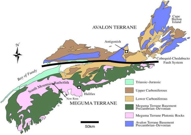
Nova Scotia’s version of the San Andreas Fault is the Cobequid-Chedabucto Fault System. It divides Nova Scotia’s two geological halves. The northern half came from Europe and the southern half from Africa. The Cobequid-Chedabucto Fault System is where they met 400 million years ago. This caused earthquakes, melted rocks and concentration of minerals like gold and zinc.
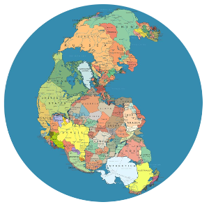
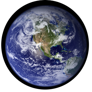
200-300 million years ago, when the continents were joined in Pangea, there was only one ocean - Pangea was a huge island in a global body of water.
As Pangea broke up, water went between continents, creating the oceans we know today. The Atlantic formed as Africa and Europe split from South America.
The Himalayan Mountains, including Everest, formed from the collision of India and Asia 50 million years ago.
India was an island drifting north about 15 cms per year - fast for a tectonic plate - until the collision pushed rock upward and created the world's tallest mountain.
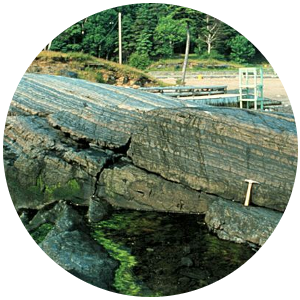
In Point Pleasant Park, Black Rock Beach's rock is sea mud and sand that were compacted into shale 450 million years ago when the North American and African tectonic plates collided.
Heat and pressure later turned the shale into slate. The layers of mud and sand are clearly visible in the rock.
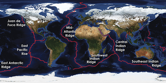
The longest mountain range on Earth is underwater.
The 65,000 km mid-ocean ridge system is the result of tectonic plates separating and magma venting through the gaps. It creates new ocean floor as the magma cools and hardens. The mid-Atlantic portion of this global ridge system widens 2-5 cm per year.
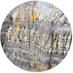
This rock in Blue Rocks, Nova Scotia, formed 400 million years ago when the North American and African tectonic plates collided.
Alternating layers of clay and siltstone at the bottom of an ancient sea were squeezed, folded and thrust upward as part of the Appalachian Mountains. The Appalachians used to be as tall as the Himalayas but are mostly eroded now.
The east coast used to be a focus of tectonic plate collisions.
The Appalachian Mountains formed 500 million years ago when North America and Africa collided. They ran from Alabama to Newfoundland but are mostly eroded now. The Cape Breton Highlands are a remnant of them.
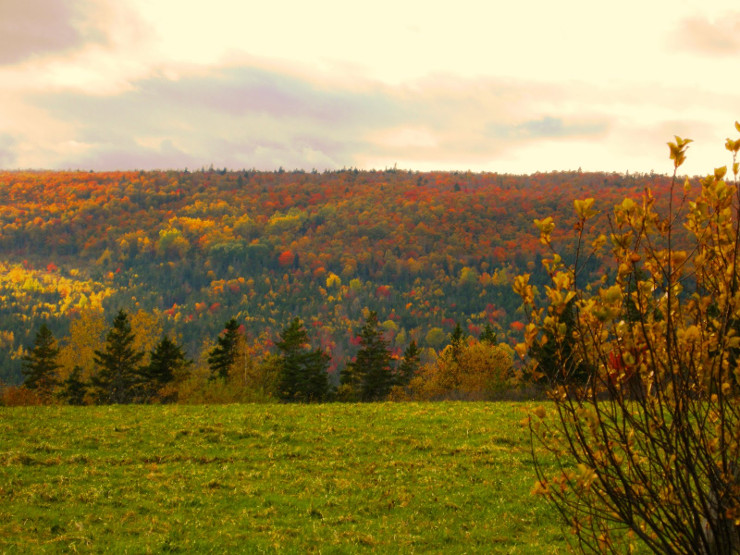
Many parts of Nova Scotia's geology formed 400-550 million years ago in the southern hemisphere, as far south as the south pole.
Nova Scotia drifted north, crossing the tropics about 350 million years ago. The salt, gypsum and coal deposits we mine today formed in tropical areas.
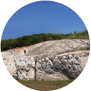
The fishermen's memorial at Peggy’s Cove is carved in granite that formed 370 million years ago.
Granite forms when magma (melted rock) rises toward the earth's surface and solidifies as it cools. Granite is the hardest sculpting stone - the memorial took ten years to do.
Fooled by Fool’s Gold!
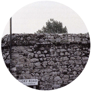
Explorer Martin Frobisher, while seeking the Northwest Passage, opened the first mine in Canada run by Europeans. He shipped 1000+ tons of ore to England in 1577-78. Sadly, it was fool’s gold (pyrite), not real gold.
Frobisher's worthless rocks ended up being used as building stone in Dartford, the English town where the unsuccessful attempts to extract gold from them took place. Hundreds were used in a wall at the Dartford manor of Henry VIII.
The geological forces that shaped our world are always active!
Canada’s most recent big volcanic eruption took place in the 1700s in British Columbia at the Tseax Cone. It was caused by two parts of the North American tectonic plate pulling apart. Lava flowed 22 kilometres and was twelve metres thick in places.
This Pacific island, Hunga Tonga, was created by an underwater volcano just four years ago. It is 500 acres and 400 feet tall at peak. It is eroding rapidly and expected to disappear within 30 years.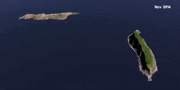
Glacial ice plucked Balancing Rock, in Tiverton, Nova Scotia, off North Mountain during the last ice age and left it in a vertical position on a flat surface as the glacier receded. Quite a fluke! It's amazing a storm (or this guy!) hasn't toppled it in the past 10-15,000 years.
By the way, “this guy” is Neal Peart, the drummer for Canadian rock icons Rush.
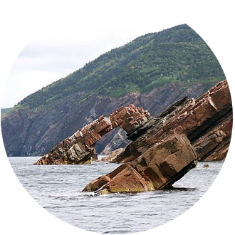
Anticline and Syncline
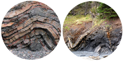 Anticline (left) and syncline (right)
Ever try to fold rock?! This rock in Rainy Cove, Nova Scotia, was folded 300 million years ago when North America and North Africa collided during the forming of supercontinent Pangea. It’s called an anticlinal fold, meaning it's arch-shaped and the oldest rock is in the centre.
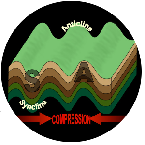
The opposite of an anticline is a syncline - when rocks are folded in a U-shape. Anticlines and synclines are found together because colliding tectonic plates cause rock to crumple into hills and valleys, like this rock which is also from Rainy Cove.
Rocks almost always form horizontally because gravity causes rock-forming material, such as lava and sediment, to lie flat. When you see tilted or folded rocks, it's because extraordinary geological forces, like tectonic plate movement, have shifted or folded them.
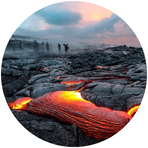
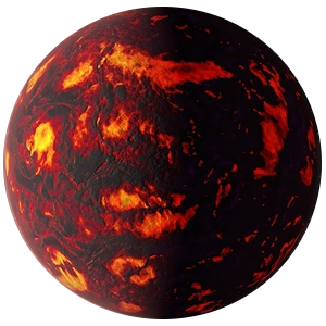
Lava and magma are the same thing: melted rock. It's called lava when it's on the earth's surface and magma when it's underground. After it's ejected from vents in the earth's surface (i.e. volcanoes), lava cools and solidifies as rock.
Many parts of Nova Scotia are rock formed from lava from ancient volcanoes, including Cape Forchu in Yarmouth County, Digby Neck, the North Mountain and much of southeastern Cape Breton including Louisburg.
The Joggins Fossil Cliffs are described in one of science's most important works, Charles Darwin's "Origin of Species."
Darwin never visited Joggins but he used its amazing fossils to explain evolution and natural selection.
Nova Scotia has extraordinary geology!
Geology Brain Teaser!
To be a mineral, something must be solid and naturally-occurring (among other things). Water isn't a mineral because it isn't solid. Ice is a mineral but only if it's frozen naturally. Ice on a pond is a mineral (because it’s frozen naturally), but ice cubes from a fridge aren't (because it’s frozen in something made by people).
Pond ice stops being a mineral when it thaws because it’s no longer solid!