- Why Mining Matters
- Jobs
- Safety
-
Environment & Operations
- FAQ
- Links
-
Fun Stuff


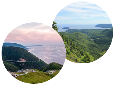
Cape Breton Highlands
Cape Breton is made of three distinct geological landscapes, or terranes.
The northwest tip (the Blair River inlier) is composed of the oldest rocks known in the Maritime Provinces. These rocks were formed 1-1.5 billion years ago during the collision of continental plates that resulted in the supercontinent Rodinia, another of the supercontinents that has existed on earth at different times. (Pangea was the most recent of the supercontinents but there have been others in the planet’s 4.5 billion year history.)
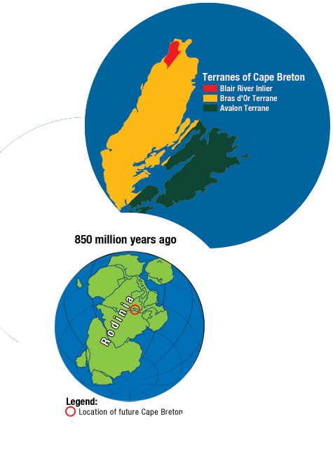
When Rodinia broke up about 750 to 450 million years ago, the continents migrated and new lands and oceans were created. During this period, the Bras d'Or terrane, which makes up most of the northern half of Cape Breton Island, began forming off the northwest coast of South America. It is a series of sedimentary and volcanic rocks.
The Avalon terrane, which makes up the southern half of Cape Breton Island, is volcanic rock that first began forming during this period on the northwest coast of what is now Africa.
The Bras d'Or terrane and the Avalon terrane were driven together about 580 to 450 million years ago as continents collided yet again.
The Blair River inlier was sandwiched together with these other two terranes to form the core of what we now know as Cape Breton Island.
The dominant feature of northern Cape Breton is the Cape Breton Plateau, averaging 350 metres at its edges but rising to more than 500 metres at its centre. The Cape Breton Plateau is part of the eroded Appalachian mountain chain which was formed about 480 million years ago and stretches 2400 kilometres from Alabama to Newfoundland. The Appalachians, like most mountains, were created by tectonic plates smashing together and forcing rock upwards with extraordinary force. 325 million years ago, the Appalachian Mountains were probably higher than the Himalayas are today but erosion has left us with only relatively modest hills in Nova Scotia from this once-great mountain chain.
The Cape Breton Plateau consists of broad, gently rolling hills, deeply cut by steep-walled river canyons and broad valleys. Much of it was shaped by glaciers.
The Bras d'Or Lakes were carved out of the bedrock by glaciers during the ice ages. Many other geological and topographical features of Cape Breton Island also owe their form to the numerous glacial advances that occurred over tens of thousands of years.
Further reading: https://www.pc.gc.ca/en/pn-np/ns/cbreton/decouvrir-discover/environ/geol...