- Why Mining Matters
- Jobs
- Safety
-
Environment & Operations

- FAQ
- Links
-
Fun Stuff


Halifax Harbour
Several million years ago, Halifax harbour was not a harbour at all - there was just a river that flowed through the area. That river was the precursor to what we now call the Sackville River. In fact, we call it the “Ancient Sackville River.” The river ran from Bedford through what we now think of as Halifax harbour, and out to the Scotian Shelf which is now part of the Atlantic Ocean. At that time Bedford Basin, Halifax Harbour and the Scotian Shelf were all dry land.
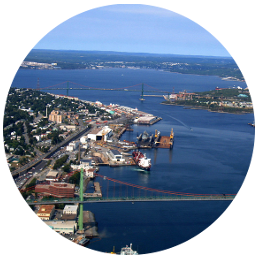
Halifax Harbour and Bedford Basin today.
Through various periods starting about two million years ago, glaciers eroded the softer rock in the harbour. This led to the formation of Bedford Basin as a giant depression and a deeper channel along the harbour. The harder rock did not erode and this left peninsular Halifax and Dartmouth as elevated land masses on the sides of the harbour.
Melting glacier water eventually became a series of lakes in depressions that had eroded in the bedrock, and these lakes were connected by a river and stream system to the ocean. As many as ten lakes once existed in the present area of the harbour.
Rising sea levels gradually moved up the harbour, connecting the lakes, and eventually flooded Bedford Basin 5700 years ago.
People tend to think that the harbour’s present shoreline is how it always was. However, ocean levels are constantly changing. In fact, during glacial times, the ocean levels were as much as 120 metres lower than they are now. This means there were many former shorelines, islands, and lakes throughout Halifax Harbour that are underwater today.
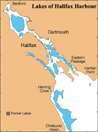
A map showing the location of 10 lakes that existed in Halifax Harbour after the glaciers left and before the sea level rose and flooded the Harbour.
(Source: http://www.bedfordbasin.ca/halifaxharbour/origin_halifax_harbour-eng.php)
(Source: http://www.bedfordbasin.ca/halifaxharbour/origin_halifax_harbour-eng.php)
Further reading: http://www.bedfordbasin.ca/halifaxharbour/origin_halifax_harbour-eng.php