- Why Mining Matters
- Jobs
- Safety
-
Environment & Operations

- FAQ
- Links
-
Fun Stuff


Sable Island
When most people think of Sable Island, they think about what’s above the water – how beautiful it is, the horses, the island’s history of shipwrecks, etc.
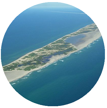
But Sable Island has an amazing story to tell underwater.
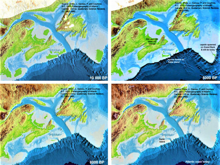
Sable Island is the top of a huge sand bank that started forming about 18,000 years ago, near the end of the last ice age, when a melting glacier left a 30-metre-tall ridge (a "moraine") at its margin.
As glaciers move, they carry gravel, sand, and clay along with them. When glaciers melt and retreat, those materials are deposited, either just dropped where they are or carried by meltwater streams to the margin where a ridge forms. The lower half of the Sable Island sand bank is largely made of sand and mud carried off a glacier by meltwater streams.
The upper half of the Sable Island sand bank is beach sand deposited by wave action on top of the bank’s lower half by rising sea levels. This activity also flattened the top of the ridge/moraine, forming a "bank."
Sea levels are lower during ice ages because so much water is frozen in glaciers. As glaciers melt and that water returns to the oceans, sea levels rise.
The Sable Island bank was initially formed when sea levels were about 100 metres lower than they are today. The moraine was likely dry and above ground. It was just a hill.
As sea levels rose, the ocean covered the moraine and washed new sand onto it. The top layer eventually got to be about 40 metres tall. The top and bottom layers of the Sable Island sand bank now have a total height of 70-80 meters.
Sable Island is about 42 kilometres long. That is roughly the driving distance from downtown Halifax to Peggy’s Cove, so the island is longer than many people realize. Even more impressive, the Sable Island sand bank is about 70 kilometres long underwater.
The images below show how rising sea levels gradually covered most of the Sable Island bank. Note how much larger the island was 10,000 years ago (before present or “BP” in the images) and how it shrank to its present size.
The Sable Island sand bank was deposited near the edge of the continental shelf. The glacier actually travelled past the edge of the shelf but stopped advancing as the deeper water caused iceberg-calving and melting.
Sandy sediment deposited by the glacier in this deep water, on the steep continental slope, slid down the slope and was moved around by currents. This prevented it forming a distinct ridge as happened when the Sable Island sand bank formed in shallower water on a more level surface.
Rising sea levels are expected to eventually cover Sable Island, just as they have the rest of the sand bank.