- Why Mining Matters
- Jobs
- Safety
-
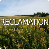
Environment & Operations

- FAQ
- Links
-
Fun Stuff


John Roderick McDougall
Farmer Miners
Gallihar and Dimock
Mr. Death
The Guilty Grenos
James Mitchell
Hugh McAskill
Gold Grows Under Shrubs?
Unexploded Dynamite
Tangier’s John Murphy
Joe Howe Dimock
Chats with Pioneer Miners
Charles Annand
John Scott Williams
Nicholas Fitzgerald
Chief Lonecloud
Pistols and Gold Mines
James MacDonald’s Thefts
John Vaughn
Herbert Dixon and the Halifax Explosion
James Bishop
Neily's Scandals
Waverley in 1934
Discovery of Gold at Dufferin
Hurricane Island
Fletcher and Faribault
Jack Munroe
Mine Apprentice Project
Small Gold Districts
15 Mile Stream
Tributers
E. Percy Brown and the Brookfield Mine
Barachois
Nova Rich Mines
Shad Bay Treasure Hunt
Montague 1937 Accident
Father Lanigan’s “Prospect”
George V. Douglas
The Stewart Brothers
Goldboro
Moose River's Touquoy Mine
Camerons Mountain
Jim Campbells Barren
Stanburne's Puzzling Gold Mine
Pockwock
Beaverbank Lake
Banook Mining Company
Deep Gold Mining
Wellington
Arsenic and Gold
Dynamite
War of Words
King of the Klondike
Oliver Millett
Kempt Gold Mining Company
Carleton
The Memramcook Fiasco
Love and Gold in Oldham
Montague 1893 Disaster
Central Rawdon Consolidated Mines
Cochrane Hill
Amateurish Early Gold Mining
Sable Island Gold
The Sea Wolf
Trueman Hirschfield
Alexander Heatherington
Prospector Joe Cope
Killag Quicksand
George W. Stuart
Wellington
Billy Bell
Cooper Jim Mine
South Branch Stewiacke
Walter Prest
Lake Charlotte
Acadia Powder Mills Company
The Ovens Anticline
Moose River Anticline
Avon Mine Explosion
Montague
Waverley Claims Dispute
Avon River
Moose River Disaster
Mooseland Scam
New York and Nova Scotia Gold Mining Company
Rosario Siroy and the South Uniacke Gold District
Blockhouse
Killag Gold District
Miller Lake
Baron Franz von Ellershausen
Mooseland: Nova Scotia’s first Gold Discovery
United Goldfields of Nova Scotia
Pleasant River Barrens Gold District
Lochaber Gold Mining Company
Rawdon Gold Mines
MacLean Brook
Gold in Clayton Park?!
Forest Hill
Meguma vs. Placer Gold
Uniacke
Voglers Cove
Gold River
Moosehead
Goldenville
Westfield
Indian Path
Harrigan Cove
Centre Rawdon
Nova Scotia’s Gold Mining History
WWII Gold
Middle River Gold District
Early Gold Discoveries
Halifax 1867
Paris Exhibition 1867
Mining and Tourism
An Act relating to the Gold Fields
Molega Gold District
Brookfield Gold District
Gays River
Halifax Gold
Caribou Gold District
Renfrew Gold District
Oldham Gold District
Whiteburn Gold District
Country Harbour Mines
Waverley Gold District
Robert Henderson and Klondike Gold
George Mercer Dawson
Cow Bay Gold District
Lake Catcha Gold District
Wine Harbour Gold District